Now that I've been away from home or any permanent sort of home for a little over a month, I feel like I have a handle on what's really needed and what's not when it comes to packing light. I'm talking about the kind of packing light where the amount of stuff you have can only fill up something the size of a daypack, the kind of backpack you'd wear to school. Of course, the climate you're heading to can be a limiting factor, and some of it assumes you'll be in urban areas in developed countries. Nonetheless, I hope my list is useful.
- A towel. Douglas Adams was right. Something, somewhere, sometime will be in a state of wetness when you want it to be in a state of dryness, and there won't be anything else around but your trusty towel. Mine is one of those compact, ultra-absorbent, quick-drying camping towels, and it's already gone far beyond its worth of $20.
-A pair of jeans. Your favorite pair of jeans. You might wear them for a week or two without washing, but they're sturdy, and it's not like anybody is going to be smelling your pants, unless you've been all but begging for that.
-A pair of shorts. These serve at least four purposes. 1. If it's hot. 2. If you want to go swimming (hopefully the shorts are good for that). 3. If you prefer to sleep in shorts. 4. When you're washing your jeans.
-Two shirts. These are both suited for the average climate of where you're heading. Too hot? Roll the sleeves up. Too cold? Put the other shirt on, on top of the one you have on now. They should be extremely durable, because they're going to be absorbing sweat, food, smoke, and more. Don't worry about the smell, because it's just what Axe Body Spray is going for these days anyway.
-Toothbrush and Toothpaste. It goes without saying, but brush after every meal, if you can. The toothpaste can also serve as mouthwash or a breathmint.
-Dental floss. You'll get stuff stuck between your teeth, and it's good hygiene to floss anyway. It can also serve as emergency string.
-Reusable Water Bottle. It doesn't matter what kind you get, and it's really your choice if you want one with BPAs floating around in it - they're delicious. Use it for water, and try to keep it full wherever you go, because you never know when you might need it. Of course, you can always fill it with some other beverages or even use it as a container when cooking.
-A non-computer with wi-fi connectivity. I use my iPod touch, and a lot of cell phones are also great for this. You can check your email, Facebook, whatever, and really, you don't need to post your pictures until you get home.
-A Jacket. Either fleece, or a combination fleece+rain jacket. Sweatshirts are far too bulky.
-A Rain Coat. Either get a compactible one that you wear on top of your jacket, or, as above, just have a warm jacket that has a waterproof layer.
-One Book, and only one. You're not going to have time to read the other one.
-Drugs: one bottle of painkillers, one bottle of stomach relief. These two should be able to fix 90% of the ailments you run into, whether you ask for them or not.
-A pen/pencil. You'll need to write notes sometimes, but you'll always be able to find something to write on, at the very least, yourself.
-All-purpose Soap. This soap can be used on your hair, body, face, clothes, and almost anything else. If think you need a bunch of cosmetics, you're never going to pack light.
-Underwear and Socks as needed. I find that 3 days per pair is the normal maximum, and you can go over if necessary. Really, unless there's dirt or bugs on the stuff, it's nothing to worry about.
I think I've left a few things out, but that brings me to another point (again, it might only apply in developed countries):
-If you leave something out, you can always get it at your destination.
Happy travels!
Thursday, September 10, 2009
Friday, August 28, 2009
On Being Cold
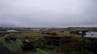
Here’s something I was pondering while sweating my guts out in Puerto Rico a few weeks ago, and while freezing my face off in the 40 degree rain while hopping across the lava rocks somewhere in Iceland: why, in the end, it’s a much more enlightening thing to feel cold and to be out in the cold rather than to be basking in the warm sun. This isn’t some moral judgment I’m making, that tanning in the tropics is sinful and you should really learn how to build an igloo. Rather, that being cold, feeling the sting of freezing rain on your face, and wishing you had brought an extra sweater allows you to better comprehend and appreciate the utter joy and miracle of your existence. Let me explain:
The human body is a highly evolved system, so highly evolved that today, in order to hop around on lava fields or trudge your way to the beach, all you need to give your body in return are a few delicious meals and a few gulps of water a day. If you go out and party, have a few drinks, and jump around and make a fool of yourself until 6am, your body will clean out your blood and heal your muscles, up to a certain point. In return, your body will ask for ten or so hours of awesome, post-party sleep.
So, in exchange for life’s basic functionality, all we need are food and sleep. And I daresay we’ve made quite and art and pleasure out of these.
When you’re cold, you can feel the tips of your nose, cheeks, fingertips, and toes going numb as your body pulls more blood and heat toward its core. At this core is your heart, the machine that supplies oxygen, heat, and energy to all the other organs, especially the brain, which in turn supplies coordination and control. These keep functioning, as long as you give them the aforementioned fuel, and as long as you keep them within certain operating temperatures.
However, let’s say you’re in the tropics. There, you could even be dead, and you’d still be lying there in the sun at about the same temperature, getting a nice tan. You’d probably be getting the same amount of work or exercise done too, and the only noticeable difference would be your decreased ability to order piña coladas.
Strange as it sounds, I actually started laughing as the wind plastered ice pellets in my face and my socks filled up with water. I was turning my attention inward to the completely fantastic machines operating inside me, keeping my innards at a balmy 98.6 degrees, and moving my lungs and legs in an efficient rhythm. Maybe even more special was the fact that, despite all this, I could see and remember the incredible landscape, hear the waterfall roaring in the distance, and smell the mix of sulfur and rain.
So, next time it’s cold outside, go out and walk around until your teeth are chattering, and be thankful for it. Then go inside, have a mug of hot chocolate and a double cheeseburger, and then take a nap.
Beautiful.

Friday, July 24, 2009
Comfort
Looking back, I realize that all the times in my life where I've had real, meaningful change and development have been times where I've been somewhere in transition, somewhere foreign and out of the usual, or somewhere genuinely uncomfortable. I never realize it at the moment; I'm always cold, hot, exhausted, dirty, and focusing on nothing more than how long and how much effort it's going to take to get back to somewhere with a bed and a cheeseburger. That is all I can think about, because I don't have the in-the-moment attention style of Virginia Woolf, but a results-based way of viewing the world. If I slipped into a conscious willing of discomfort, then it would be the solution, but would also go against the deep grain of human nature.
Humans are the first sedentary creatures, and this gives us unique problems like technology and philosophy that no other species has the "luxury" for. Our stone age ancestors used our drive for comfort as a necessity. Wanting shelter, food, and fire fueled our drive for them, and those who could get it built upon their life, evolution, and success for centuries until we had taken care of our basic necessities and started building inventions and civilizations. But once we've reached our "modern" level of development, our quest for comfort becomes our downfall. The best example of this is widespread obesity, especially in this country. Early humans ate all they could get their hands on, always bingeing because they didn't know where their next meal would come from. As we started to lock down our basics, we developed agriculture and domestication, now to the point of our modern food industry. We don't have to hunt and gather anymore, but we still eat as if it were our last meal for a long time.
Sedentary culture means that we have the ability to sit down and write about things like this, and that there are things like this to write about in the first place.
But what am I going to have to do to attune myself to a life of voluntary discomfort and basic urgency? I already recognize its value after the fact, seek out these experiences before the fact, and miss them when I'm full, cushioned, and bored. The last piece in the tetrad is presentist, conscious actualization. I have no choice but to be up to the challenge.
---
I was just reading an introduction to Moby Dick, and it had a quote from the book:
Or Thoreau, in Walden, in just one sentence:
Humans are the first sedentary creatures, and this gives us unique problems like technology and philosophy that no other species has the "luxury" for. Our stone age ancestors used our drive for comfort as a necessity. Wanting shelter, food, and fire fueled our drive for them, and those who could get it built upon their life, evolution, and success for centuries until we had taken care of our basic necessities and started building inventions and civilizations. But once we've reached our "modern" level of development, our quest for comfort becomes our downfall. The best example of this is widespread obesity, especially in this country. Early humans ate all they could get their hands on, always bingeing because they didn't know where their next meal would come from. As we started to lock down our basics, we developed agriculture and domestication, now to the point of our modern food industry. We don't have to hunt and gather anymore, but we still eat as if it were our last meal for a long time.
Sedentary culture means that we have the ability to sit down and write about things like this, and that there are things like this to write about in the first place.
But what am I going to have to do to attune myself to a life of voluntary discomfort and basic urgency? I already recognize its value after the fact, seek out these experiences before the fact, and miss them when I'm full, cushioned, and bored. The last piece in the tetrad is presentist, conscious actualization. I have no choice but to be up to the challenge.
---
I was just reading an introduction to Moby Dick, and it had a quote from the book:
"The port would fain give succor; the port is pitiful; in the port is safety, comfort, hearthstone, supper, warm blankets, friends, all that's kind to our mortalities. But in that gale, the port, the land, is that ship's direst jeopardy; she must fly all hospitality;... With all her might she crowds all sail off shore... seeks all the lashed sea's landlessness again; for refuge's sake forlornly rushing into peril; her only friend her bitterest foe!"Herman Melville said in one metaphor what it took me an entire page to get across.
Or Thoreau, in Walden, in just one sentence:
"Most of the luxuries, and many of the so-called comforts of life, are not only not indispensable, but positive hindrances to the elevation of mankind. "
Tuesday, February 10, 2009

Monday, January 19, 2009


Saturday, December 13, 2008

Monday, December 8, 2008
GIS Final Project
Using Archived Aerial Photographs for Coastline Erosion Analysis at Double Bluff, Whidbey Island, Washington
This project was an attempt to map areas of coastline erosion on the Double Bluff area of Whidbey Island, Washington, using a series of aerial and satellite photos. It was also a case study to determine whether archived physical raster data alone could be used accurately and effectively in a vector-based analysis of a dynamic process. This kind of analysis is an exploration of concepts in physical geography, specifically, the evolution of glacially-sculpted landscapes. I’ve been fortunate enough to be introduced to these concepts through ESS 209, an Exploration Seminar to Greenland, and have studied the glacial history of Puget Sound and especially Whidbey Island in ESS 302 – “The Great Ice Age” through lectures, maps, lab exercises, and even a field trip to the area in question. This sort of process analysis is quickly becoming more important as global climate change and sea level rise begin to melt and erode polar coastlines and threaten low-lying coastal communities worldwide.
For this project, remotely sensed data needed to be of a small enough scale to run detailed analysis on an area only a few miles long – a satellite image of the entire United States would not be effective. I discovered that Washington State-level agencies generally had plenty of images at the scale of subsections of counties. For this project, I used photos from the Washington State Dept. of Transportation, NASA, the U.S. Agricultural Stabilization and Conservation Service, and the Washington Dept. of Natural Resources, all via the UW Map Collection. The photos were no larger than a normal sheet of paper, and were scanned into .TIF format at 600dpi. Unfortunately, with some of the aerial photos only a few inches in length and width, the average raster resolution was not particularly sharp. Luckily, the contrast between beach sand and trees on the island was high enough that resolution did not prove to be a significant obstacle for marking coastlines.
In order to make a consistent determination of coastline position, all raster data had to be georeferenced to account for photographic distortion. I downloaded an ESRI Census 2000/TIGER roads vector layer and georeferenced rasters based on road intersections, taking care to give preference to intersections near to coastlines to minimize the distortion in this key project area.
 Georeferencing the aerial photo using the Roads vector layer as the primary reference
I created a vector line layer for each of my raster images, using ArcMap’s edit mode to manually place nodes. Each aerial photo and its vector coastline are visible in the map “Double Bluff, Whidbey Island Coastlines: 1966-1995” I graduated the color scheme for each coastline based on the date of the raster; choosing a readable and clear color scheme was one of the more difficult components of displaying the vector layers, as visibility was important for not only the map reader’s comprehension, but also for my own ability to use the layers to spot change over time.
 Creating coastline vector layers in Edit mode
 Displaying coastlines from all four aerial photos
I then displayed all of the vector layers on top of one another in order to determine consistent areas of erosion. The result is visible in the “Double Bluff, Whidbey Island Coastline Composite, 1966-1995” map. At this point, it became clear that the dimensions of distortion due to georeferencing had almost completely overwhelmed the dimensions of possible erosion, meaning that coastline vectors frequently crossed and rarely displayed a smooth, logical progression inwards over time. It was at this point that Tim and I decided that a mathematical analysis would be practically ineffective, and that visual determination of erosion would be the only analysis method that is even remotely reputable with this data. For the sake of accuracy, I did not calculate the total area lost to erosion (this number would be pointless). I simply did my best to identify areas where erosion appeared to be significantly inward and consistent over time, despite distortion. These results are displayed in the “Likely Erosion Areas” map.
 The composite of all four coastline vectors. Note the overlapping and inconsistent change between years.
 Estimating erosion areas for future study
The apparent failure of the originally proposed techniques in this project highlights a number of crucial data theory, geographic, and scientific concepts. First, no matter how much cleaning up is done after collection, some data is simply too old or low-resolution to enable meaningful analysis on any processes not already blindingly apparent. Next, distortion due to projection can, in fact, be another significant obstacle to detailed analysis. Despite these obstacles, the compilation of this data did result in the identification of two areas that may have experienced erosion and warrant further study. If a subsequent project were to be launched with more refined and accurate data, the results of the first project would certainly give those two areas precedence.
This project did manage to create several data sets of the Double Bluff area and its coastline, albeit with a few imperfections. Even in the GIS-rich State of Washington, it’s surprising how much historical and raster data has yet to be digitized. The project implemented several methods for digitizing this archived data for later analysis, and brought in outside questions to try to visualize a real-world process with real implications. The biggest improvement that could have been done would have been consistent standards (resolution, scale, projection) for remotely sensed data from all involved agencies since the beginning of its collection in this area in the 1940s – a tall order, and something we certainly can’t change now.
If I were in charge of future analysis in this area, I would recommend data collection by GPS in the field done continuously, over consistent intervals. Measuring coastline is by far more accurate with points taken on-site, rather than from 10,000 feet up in the air, 40 years later. This sort of continuous data, combined with already-existing topographic data (DEM, LIDAR, USGS topo) regarding slope and elevation, would be useful in modeling future erosion in the area as well. This project has shown that, in this case, an armchair analysis of data not specifically designed and intended for coastline analysis is not the most accurate, useful, or effective means for answering the proposed question, though it provides a good starting framework for future work.
Subscribe to:
Posts (Atom)
